Settlement-Level Risk Maps for Kula Norinska (Croatia) and Neum (Bosnia and Herzegovina)
1. Project Background
The CLIMAAX project (Climate Risk and Adaptation Assessment for Local Authorities) is an EU Horizon Europe initiative that develops standardized climate risk assessment frameworks for European regions. This engagement encompasses two projects: (1) Climate Risk Assessment and Adaptation Strategies for Kula Norinska Municipality in Neretva Delta, Croatia, and (2) Climate-Smart Neum: A Multi-Risk Assessment for Sustainable Coastal Development. Both projects delivered Phase 2 Financial Support to Third Parties (FSTP2) for the Municipality of Kula Norinska, Croatia, with an expansion into the neighboring Municipality of Neum, Bosnia and Herzegovina, and technically end on 31st of December 2026.
The core requirement was to adapt the standard CLIMAAX NUTS3-level methodology to the settlement level—the scale at which local governments make decisions about adaptation planning, infrastructure investment, and emergency preparedness.
2. Study Area
Kula Norinska is a municipality comprising nine settlements in the Neretva River delta in southern Croatia, with extensive Natura 2000 coverage. Neum is a coastal municipality comprising 27 settlements in Bosnia and Herzegovina. The two municipalities are separated by the Neum-Klek corridor, which provides Bosnia and Herzegovina with its only access to the Adriatic Sea.
The cross-border setting introduced several real-world data challenges: no settlement polygons for Bosnia and Herzegovina were publicly available in OpenStreetMap; EU-only datasets, including Urban Atlas and Natura 2000, were unavailable for Neum; and the two countries use different coordinate reference systems (EPSG:3765 for Croatia and HR_GK_6 / MGI1901 for Bosnia and Herzegovina).
Settlement boundaries for Neum were obtained as an official cadastre shapefile from the Federal Geodetic Administration (FGU) of Bosnia and Herzegovina through project collaboration.
3. Hazard Domains
Three hazard domains were assessed across 36 settlements.
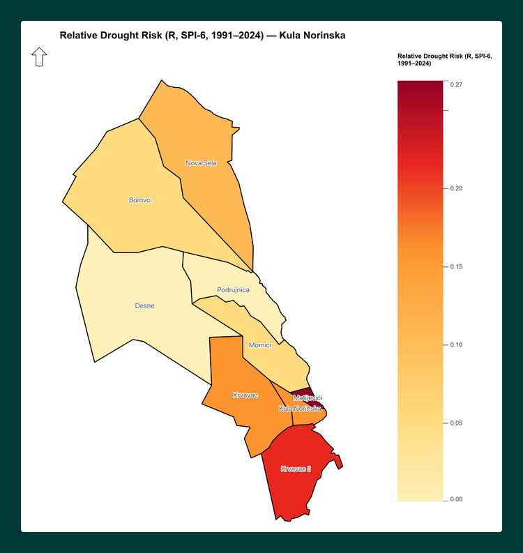
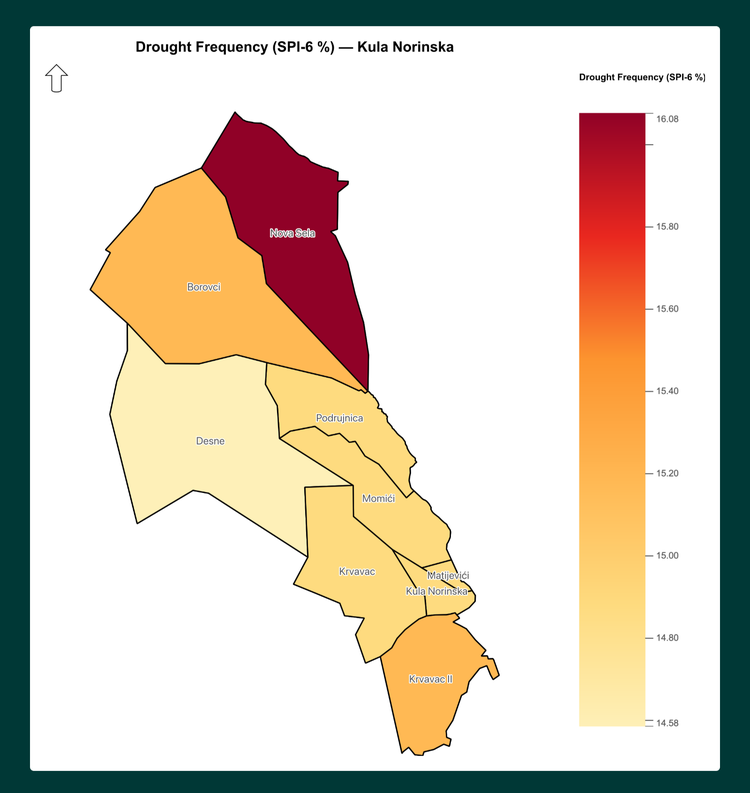
For droughts, settlement-level meteorological drought risk was computed using the six-month Standardized Precipitation Index (SPI-6) from 22 stations: three local meteorological stations (DHMZ Opuzen, DHMZ Metkovic, and FHMZ Neum) and 19 ERA5-Land reanalysis grid points accessed via the Open-Meteo API, covering the period 1991–2024.
Station-level drought metrics were interpolated to settlement centroids using Inverse Distance Weighting. The risk formula followed the CLIMAAX framework: Risk = Hazard × Exposure × Vulnerability, with each component normalized to a 0–1 scale.
Future drought projections under six climate scenarios—SSP126, SSP370, and SSP585 for the near-term period 2011–2040 and the far-term period 2041–2070—were generated using CHELSA V2.1 CMIP6 climatologies at 1-kilometer resolution, with the delta-change method applied to the ERA5-Land baseline.
A multi-indicator vulnerability proxy was used, incorporating agricultural land, population density, built-up surface, water cover, and protected areas, because settlement-level socioeconomic data were not available.
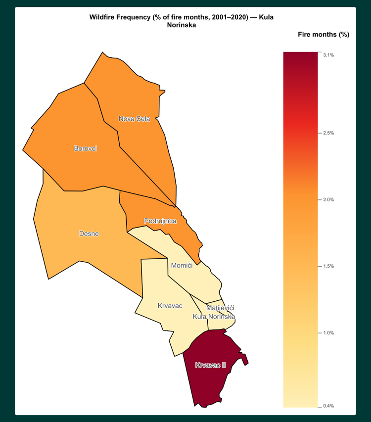
For wildfires, two parallel methodologies were applied. The first was a custom machine-learning pipeline using FireCCI51 burned-area data (MODIS, 2001–2020), processed into per-settlement fire-frequency, severity, and burned-area metrics. These metrics were combined with CHELSA CMIP6 climate predictors to produce historical and future wildfire susceptibility under six scenarios, classified into six hazard classes.
The second methodology followed the standard CLIMAAX Fire Weather Index workflow using CDS seasonal FWI data, ESA-CCI land-cover data, and EFFIS vulnerability rasters for FWI-based hazard classification at the settlement level.
For heatwaves, the EuroHEAT health-based methodology was applied using pre-downloaded CDS heat- and cold-spell data (eight NetCDF files, 816 MB, covering RCP4.5 and RCP8.5), combined with EURO-CORDEX temperature projections for future heatwave frequency, intensity, and duration at the settlement level.
4. Data Overview
The data stack spans multiple spatial resolutions and sources. Precipitation data came from DHMZ and FHMZ meteorological stations, using monthly totals for 1991–2024, and from ERA5-Land reanalysis at 0.1-degree resolution.
Population data were sourced from the Global Human Settlement Layer GHS-POP R2023A at 100-meter resolution, produced by the Joint Research Centre of the European Commission. Built-up surface data came from GHS-BUILT-S E2020 at 100-meter resolution.
Land-cover data were sourced from Corine Land Cover 2018, which has a 25-hectare minimum mapping unit, and were accessed via the EEA ArcGIS MapServer REST API.
Future climate projections were obtained from CHELSA V2.1 CMIP6 cloud-optimized GeoTIFFs hosted on S3 at 1-kilometer resolution. Burned-area data came from the ESA Climate Change Initiative FireCCI51 v5.1 product at 500-meter resolution and were automatically downloaded from the CEDA archive.
Fire weather indices were obtained from the Copernicus Climate Data Store seasonal FWI dataset, together with EFFIS vulnerability rasters. Heatwave definitions and projections used the CDS EuroHEAT dataset combined with EURO-CORDEX temperature data.
Administrative boundaries were sourced from Natural Earth at a 1:10 million scale, official DGU Croatia municipality boundaries, and OpenStreetMap settlement polygons for Croatia.
All spatial data were reprojected to EPSG:3765 (HTRS96/TM) to ensure cartographic consistency. The complete, organized data archive contains more than 250 files across 11 domain categories.
5. Deliverables
Each map was generated automatically using PyQGIS scripts in QGIS 4.0.3, ensuring consistent layouts, legend styles, color palettes, and map-element placement across all outputs.
The drought work included historical risk maps covering 10 themes: frequency, severity, combined hazard, population density, agricultural land, built-up surface, Natura 2000 coverage, drought risk, municipality-level frequency, and municipality-level hazard. It also included six future-scenario maps.
The heatwave work produced EuroHEAT-based hazard maps for the Neum settlements.
The drought work included historical risk maps covering 10 themes: frequency, severity, combined hazard, population density, agricultural land, built-up surface, Natura 2000 coverage, drought risk, municipality-level frequency, and municipality-level hazard. It also included six future-scenario maps.
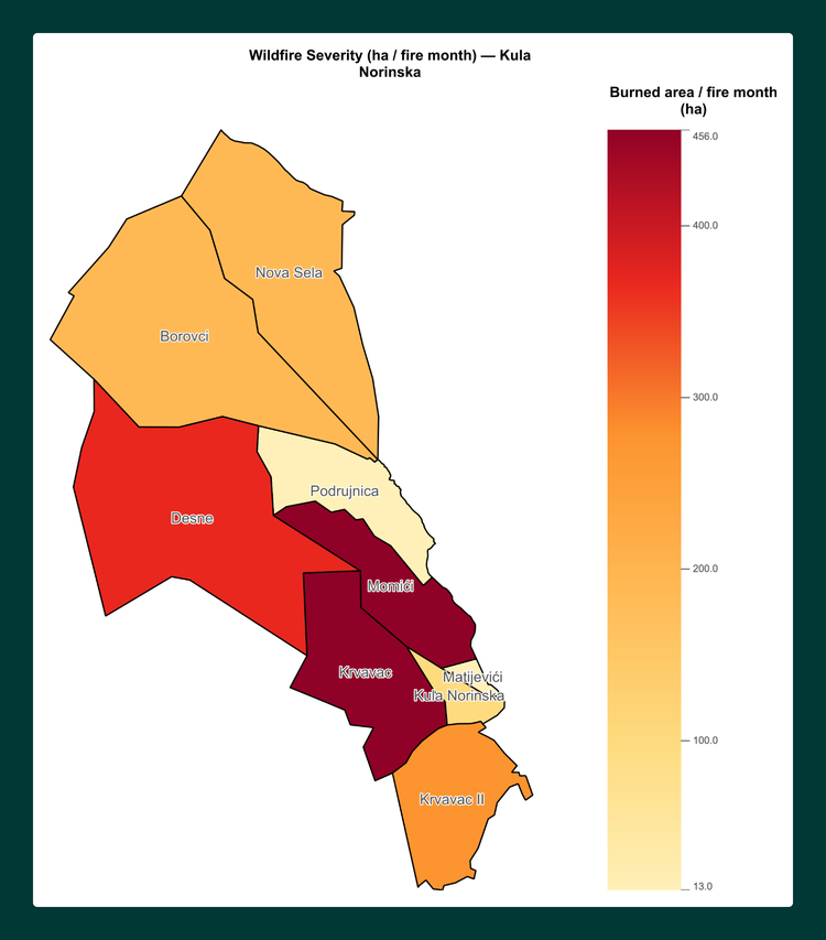
The wildfire work included fire-theme maps covering frequency, severity, burned area, and people-per-hectare exposure, together with six hazard-scenario maps for each settlement group. Each was classified into six hazard classes ranging from very low to extreme.
6. Relevance for Other Clients
This project demonstrates a proven capability to produce settlement-level climate risk assessments across multiple hazards using diverse and imperfect data sources in a cross-border setting where EU and non-EU data standards intersect.
The methodology is directly applicable to municipalities and local governments that require climate adaptation planning at the settlement scale rather than at the coarser NUTS3 level.
It is also relevant to development agencies working in cross-border regions with uneven data availability; environmental consulting firms producing multi-hazard risk assessments at scale; infrastructure operators requiring asset-level climate exposure mapping; insurance and reinsurance companies requiring settlement-level hazard classification; and non-governmental organizations identifying vulnerability hotspots in data-sparse regions.
The technical approach is built on open-source tools, including QGIS, Python, and GeoPandas; cloud-optimized data formats such as COGs hosted on S3; and reproducible auto-download pipelines that minimize local storage requirements.
All cartographic production is fully automated through PyQGIS scripts, enabling rapid scaling from 36 settlements to hundreds or thousands of settlements without additional manual effort for each map.
What our clients say
Hear directly from the people we work with about the experience, the collaboration, and the results.
Work
Each of our projects starts with a business problem. Here's what happens next.
Haas Tooling
E-commerce | AEM | Performance & Optimization



Haas Automation
Automation | E-commerce